Pictorial Map of Israel - 23.4 x 16.5 inches - Paper Laminated
Desde $14 /mes
Total: $57
Marca
Tiger Moon The Tiger Moon Trading Company Ltd
Categoria
MapsTiempo de entrega estimada Martes 21 de abril al Sábado 25 de abril.
Precio
$57
Compra segura
Proteccion total en tu pago y tu pedido.
Pago seguro
Multiples medios de pago disponibles.
Envio verificado
Cobertura nacional con seguimiento en cada etapa.
Tiempo de entrega estimada Martes 21 de abril al Sábado 25 de abril.
Compras Empresariales — Maps
Solicite una cotizacion para su empresa
Geography de la marca Tiger Moon The Tiger Moon Trading Company Ltd con 14.4 x 25 inches
Tienes dudas? Preguntale a mIA
Asistente de compra personalizado por WhatsApp
Preguntas rapidas para mIA sobre Tiger Moon The Tiger Moon Trading Company Ltd o tu compra
Pregunta sugerida sobre Mississippi State Physical Map - 14.4 x 25 inches - Paper Laminated ¿Este producto sí me sirve para lo que necesito?
Pronto nos pondremos en contacto contigo.
Gracias por elegir Yaxa!
Desde $14 /mes
Total: $57


Desde $10 /mes
Total: $41

Desde $11 /mes
Total: $42
Geography de la marca Tiger Moon The Tiger Moon Trading Company Ltd con 14.4 x 25 inches
¿De qué marca es?
Tiger Moon The Tiger Moon Trading Company Ltd.
¿Qué color tiene?
full.
¿Cuánto pesa?
5 oz.
¿Cuáles son sus dimensiones?
17.72 x 2.13 x 2.13 pulgadas, aproximadamente 45.0 x 5.4 x 5.4 cm.
¿Desde cuándo está disponible?
Desde julio de 2022.
| Campo | Valor |
|---|---|
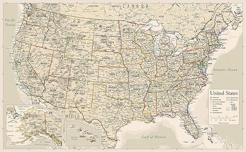
| Sheet | 14.4 x 25 inches |
| Paper Finish | Coated |
| Best Sellers Rank | #186,911 in Office Products (See Top 100 in Office Products) #574 in Wall Maps |
| SKU | B0B7X1PV2S |
| Modelo | Mississippi |
Explore the geography and charm of Mississippi with this detailed and visually engaging physical map. Bordered by the mighty Mississippi River to the west and the Gulf of Mexico to the south, the state offers a rich tapestry of natural features and cultural landmarks. From the rolling hills of the northeast to the coastal lowlands, this map highlights the terrain, rivers, roadways, and cities across the Magnolia State. Featuring the capital city of Jackson along with other major towns, this map is an excellent educational and decorative resource. Whether you're a student, teacher, history enthusiast, or traveler, it offers a comprehensive look at the state’s natural layout and infrastructure. Capital and major cities, rivers, roads, and elevation detail Clear, legible text with vibrant color contrast Great for classrooms, study spaces, offices, or as a conversation piece Printed on high-quality paper with a glossy laminate finish for added durability Bring Mississippi into focus and enjoy a top-down view of one of the South’s most historically and geographically rich states.
Valoraciones
7